RESERVADOS TODOS LOS DERECHOS Prohibida la reproducción, total o parcial de los contenidos de la web de la Cartografía Histórica de Andalucía, por cualquier medio bien sea mecánico o electrónico, sin la autorización previa y por escrito del Instituto de Estadística y Cartografía de Andalucía. Los mapas, planos o vistas históricas suministrados por este medio son propiedad exclusiva de sus respectivos organismos depositarios, por lo que la copia facilitada por el Instituto de Estadística y Cartografía de Andalucía solo podrá ser utilizada con fines exclusivos de investigación. En los casos de uso para publicación, edición o exhibición públicas, la obligatoria autorización corresponde solicitarla ante el titular legal de los derechos, de conformidad con la Real Decreto Legislativo 1/1996, de 12 de abril, por el que se aprueba el Texto Refundido de la Ley de Propiedad Intelectual.
POLÍTICA DE PROTECCIÓN DE DATOS En cumplimiento de lo dispuesto en la Ley Orgánica 3/2018, de 5 de diciembre, de Protección de Datos Personales y garantía de los derechos digitales, que adapta el ordenamiento jurídico español al Reglamento (UE) 2016/679 de 27 de abril de 2016 relativo a la protección de las personas físicas en lo que respecta al tratamiento de datos personales, le informamos:
- La responsable del tratamiento de sus datos personales es la Subdirección del Área de Coordinación, Comunicación y Métodos: resprat.ieca@juntadeandalucia.es. El contacto del Delegado de Protección de Datos es: dpd.ieca@juntadeandalucia.es
- La finalidad del tratamiento es gestionar su solicitud o petición.
- La base jurídica del tratamiento está recogida en el artº 6.1.e del Reglamento (UE) 2016/679.
- Puede ejercer sus derechos de acceso, rectificación y supresión, portabilidad de sus datos, y la limitación u oposición a su tratamiento ante el responsable del tratamiento.
-
Puede encontrar
información detallada en:
http://www.juntadeandalucia.es/institutodeestadisticaycartografia/protecciondedatos/index.html
CONDICIONES GENERALES Mediante este aviso legal y de conformidad con lo establecido en la Ley 34/2002 de 11 de julio de Servicios de la Sociedad de la Información y Comercio Electrónico, el Instituto de Estadística y Cartografía de Andalucía informa al usuario que el envío de la solicitud de productos cartográficos implica la aceptación de las condiciones del servicio. A este efecto, el Instituto de Estadística y Cartografía de Andalucía pone a disposición de los usuarios la dirección de correo electrónico cartoteca.ieca@juntadeandalucia.es y el teléfono 900 101 407 a fin de facilitar la identificación y la corrección de errores en la introducción de datos. Con renuncia expresa de su propio fuero, las partes se someten a la jurisdicción de los juzgados y tribunales de Sevilla. La utilización indebida de esta aplicación dará lugar a las correspondientes responsabilidades.
| Código | Indicador | Subcampos |
|---|---|---|
| 001 | IECA1988014407 | |
| 005 | 19911117230000 | |
| 007 | aj-aanzn | |
| 008 | 911118q17021799espXXaXXXbXzxengdm 6f6af | |
| 034 | 1# | $aa$b33068 |
| 035 | ## | $6https://www.ign.es/web/ign/portal$aInstituto Geográfico Nacional (Madrid). 32-D-5 |
| 041 | 0# | $aspa |
| 045 | 0# | $b1702 |
| 130 | ## | $aCádiz (Bahía)$f1702$kBatallas |
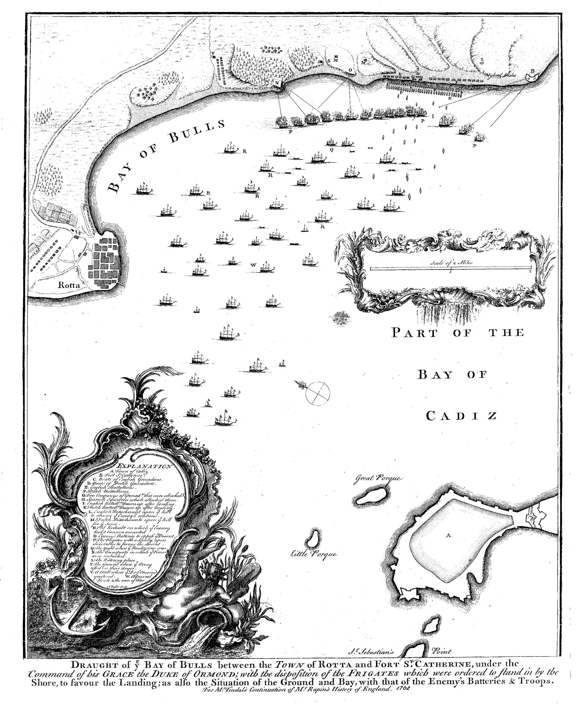
| 245 | ## | $aPart of the Bay of Cadiz$bDraught of ye Bay of Bulls betwen the town of Rotta and Fort St Catherine, under the command of his Grace the Duke of Ormond, with the disposition of the figates which were ordered to fland in by the shore, to favoor the lading is alfo the situation of the Ground and Bay, with that of the Enemy's Batteries & Troups &$cFor Mr. Tindals Continuation of Mr Rapin's History of England |
| 255 | ## | $aEscala [1:33.068 ] 2 Miles [=11,2 cm] |
| 260 | ## | $c1702 |
| 300 | ## | $a1 mapa$bgrabado papel b y n$c51 x 40 cm |
| 500 | ## | $aEjemplar grabado entre 1702 y 1800 (según propietario | 500 | ## | $aAparece suelto pero posiblemente perteneciese al libro aludido en la mención de responsabilidad | 500 | ## | $aOrientado al norte mediante flecha | 500 | ## | $aAparecen dibujadas las flotan con barcos y un plano posiblemente irreal de la ciudad de Rota | 500 | ## | $aLa escala viene rodeada de orla muy artística | 500 | ## | $aCon índice de letras referidos a topónimos y flotas y fuertes etc | 500 | ## | $aEn buen estado | 500 | ## | $aNo aparece taller de grabado |
| 534 | ## | $e1 mapa grabado papel b y n 51 x 40 cm | 534 | ## | $pVersión original |
| 650 | 17 | $aBatallas |
| 651 | #7 | $aCádiz (Municipio) | 651 | #7 | $aCádiz (Bahía$zCádiz) | 651 | #7 | $aRota (Municipio, Cádiz) |
| 710 | 1# | |
| 856 | 4# | $uhttp://www2.ign.es/fondoscartograficos/Cartografias_G/0648_32-D-5.jpg |
| 906 | 0# | $b1702 |
Rota (Municipio, Cádiz)